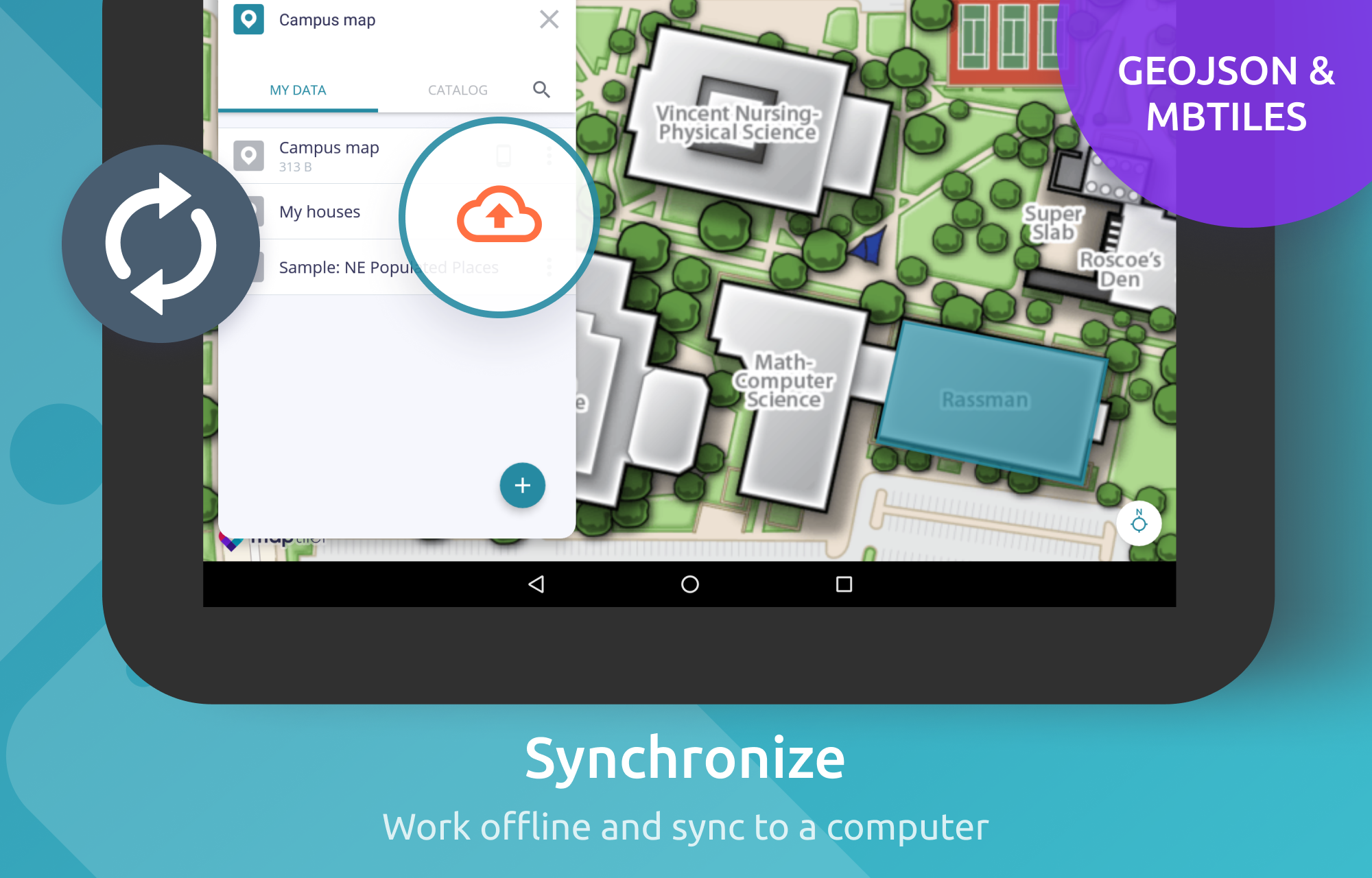
MapTiler Mobile

1.0 16

v2.1.8 by Klokan Technologies GmbH

MapTiler Mobile アプリダウンロード MapTiler Mobile アプリダウンロード

MapTilerの詳細

Klokan Technologies GmbHからリリースされた『MapTiler』は地図&ナビアプリだ。apkfab.com/jpから『MapTiler』のファイルサイズ(APKサイズ):26.79 MB、関連ムービー、pv、スクリーンショット、詳細情報などを確認できる。apkfab.com/jpではKlokan Technologies GmbHより配信したアプリを簡単に検索して見つけることができる。『MapTiler』に似ているアプリや類似アプリは200個を見つける。旅行&地域というのタッグは『MapTiler Mobile』を含む。現在、MapTiler Mobile appのダウンロードも基本プレイも無料だ。『MapTiler』のAndroid要件はAndroid 5.0+なので、ご注意ください。APKFabあるいはGooglePlayから『MapTiler Mobile apk』の最新バージョンを高速、安全にダウンロードできる。APKFab.com/jpでは全てのAPK/XAPKファイルがオリジナルなものなので、高速、安全にダウンロードできる。
See your GPS position on your own maps. Draw points, polygons and lines on the maps. Collect field data and notes related to a location, attach a photo and fill custom properties.
Display offline maps generated with MapTiler (https://www.maptiler.com).
Choose from various basemaps like street and satellite. Preview on a mobile device the map you previously designed with own colors and fonts in MapTiler Cloud.
The app supports GeoJSON and MBTiles formats and data synchronization between multiple devices and desktop computer using cloud. I it easy to share the data with other people and collaborate! Perfect for mobile data collection for GIS and surveys.
Import scanned hiking maps, PDF maps, drone aerial imagery, nautical charts for sailing and navigation with a boat or a yacht, fishing maps, aeronautical charts for flight planning by pilots, parcels and city plans and other opendata from local government. OpenStreetMap vector maps are powered by OpenMapTiles project (the successor of OSM2VectorTiles). Maps can come from existing tile servers with OGC WMTS, TileJSON or XYZ tiles from.
Supported geodata formats by MapTiler: GeoTIFF, TIFF, JPEG, ECW, SID / MrSID, NOAA KAP / BSB, DEM, OziExplorer OZI OZF2 & OZFX3, WebP, JP2, JPEG2000, GeoJP2, Erdas, Grass, Safe, Sentinel2, SRTM, NASA imagery, USGS map sheets, exports from ESRI ArcGIS, ArcSDE, etc.
The GeoJSON can be converted from / to: ESRI ShapeFile (SHP), DXF, DWG, GPX, CSV and KML.

MapTiler 2.1.8 アップデート

Upgrade to MapLibre 8.4.0
続きを読む
MapTiler 特徴
関連動画
バージョン履歴 もっと見る
MapTiler Mobile
MapTiler Mobile 2.1.8 APK
2021年04月08日 26.79 MB

Requires Android: Android 5.0+

Architecture: arm64-v8a, armeabi-v7a, x86, x86_64

Screen DPI: 120-640dpi

SHA1: d5c01026c1db3911af878d82584fbda75b33af2e

Size: 26.79 MB

What's New:

Upgrade to MapLibre 8.4.0
MapTiler Mobile
MapTiler Mobile 2.1.8 XAPK APKs
2021年08月18日 21.19 MB
Variant
Arch
Version
DPI
arm64-v8a
Android 5.0+
160-640dpi
armeabi-v7a
Android 5.0+
160-640dpi
MapTiler Mobile
MapTiler Mobile 2.1.6 APK
2021年01月08日 26.81 MB

Requires Android: Android 5.0+

Architecture: arm64-v8a, armeabi-v7a, x86, x86_64

Screen DPI: 120-640dpi

SHA1: 492c411a2bf9b48a86c1702521eacebab13f8859

Size: 26.81 MB

What's New:

Migrated to maplibre native library and fixing error which caused raster mbtiles stored on the device were not displayed.
MapTiler Mobile
MapTiler Mobile 2.1.5 APK
2020年12月19日 26.79 MB

Requires Android: Android 5.0+

Architecture: arm64-v8a, armeabi-v7a, x86, x86_64

Screen DPI: 120-640dpi

SHA1: 65ff7f75eec44a725add35a9641438e666c04c61

Size: 26.79 MB

What's New:

Bug fixes
追加情報

パケージ名:

com.maptiler.geoeditor

更新日:

最新バージョン:

2.1.8

バージョンアップ申請:

最新版提出

Android要件:

Android 5.0+