About Y!マップ
Y!マップ (Package Name: jp.co.yahoo.android.apps.map) is developed by Yahoo! JAPAN (LY Corporation) and the latest version of Yahoo!マップ - 最新地図、ナビや乗換案内も 8.69.0 was updated on October 22, 2025. Yahoo!マップ - 最新地図、ナビや乗換案内も is in the category of Maps & Navigation with the feature Travel & Local. You can check all apps from the developer of Yahoo!マップ - 最新地図、ナビや乗換案内も and find 42 alternative apps to Yahoo!マップ - 最新地図、ナビや乗換案内も on Android. Currently this app is for free. This app can be downloaded on Android 9.0+ on APKFab or Google Play. All APK/XAPK files on APKFab.com are original and 100% safe with fast download.
◆Features of Yahoo! Maps◆
・Map design that will not get you lost: Easy-to-read text and icons allow you to quickly find the information you want.
・Easy-to-understand navigation: Turn-by-turn navigation is used for car, bicycle, and walking. You can reach your destination without getting lost.
・Theme maps: Dedicated maps for different purposes such as "Ramen Map" and "EV Charging Spot Map".
・Congestion forecast: You can see the congestion around the facility and on the train.
■Map design that will not get you lost, perfect for walking around the city
・Text and icons are clear and large, and roads and buildings are simply represented. The information you want catches your eye at a glance.
・Full of information you need when actually walking, such as facilities with prominent signs and subway entrance and exit numbers.
・Indoor map with detailed information on major stations and underground malls. You can move around with confidence with maps for each floor.
■"Route search" that shows the route and time required to your destination
・You can choose from six transportation methods for route search: car, public transportation, bus, walking, bicycle, and flight.
- You can choose from three types of car routes: "recommended," "highway priority," and "regular priority."
- You can choose from "fastest," "cheapest," and "fewest transfers" for public transport routes.
- You can see the location and delay times of trains and buses in real time.
- You can check the state of rain clouds up to six hours ahead by overlaying a rain cloud radar on your walking and cycling route.
- You can purchase tickets from the search results for public transport and flights.
■Simple and easy-to-understand "navigation"
- Turn-by-turn navigation guides you to your car, walking, and cycling route.
- You will be guided to your destination with easy-to-understand route lines drawn on the map, guide panels such as "Turn right at ◯◯" and "Turn right in ◯m" at the top of the screen, and voice guidance to your destination.
- Even if you go off the road, the auto-reroute function automatically searches for a new route, so you can proceed safely.
・The car navigation system searches for routes that take into account traffic congestion information and road closures, and also provides illustrations of highway entrances and exits, junctions, and major intersections in designated cities.
・Toll fees are displayed for highway routes.
・Connect to an Android Auto-compatible display audio and get smooth route guidance to your destination on a large screen.
■"Theme Map" displays only information that suits your purpose
・"Ramen Map" allows you to find your favorite ramen from ramen shops across the country.
・"EV Charging Spot Map" shows information such as fees and charging types at facilities where you can charge your electric vehicle (EV).
・"Coupon Map" shows shops with coupons.
・In addition, dedicated seasonal maps show information on nature and events unique to that season.
■"Genre Search" allows you to find shops you can go to right away
・Tap on a genre such as gourmet, cafe, convenience store, or parking to see nearby shops on a map or in a list of photos.
・Pin the shop name, number of reviews, and more on the map. Easily find the shop you're interested in by location.
・On the details screen, you can check more detailed information such as the shop's address, phone number, business hours, and photos.
■Register information you want to see later in "Registered Spots"
・You can save shops and facilities you're interested in in "Registered Spots". (※1)
・Facilities registered in "Registered Spots" are displayed as icons on the map.
・"Registered Spots" can be divided into groups according to purpose, such as travel and gourmet.
・You can write your own information using the memo function.
・Information saved on your computer can also be viewed in the app.
■"Raincloud Radar", "Weather Card", and "Raincloud Card" show the weather and movement of rainclouds
・Equipped with a raincloud radar that supports "high-resolution precipitation nowcast". Displays the movement of rainclouds all over the country in high definition, and shows the movement of rainclouds and precipitation amounts for up to 6 hours ahead. (※1)
・"Weather Card" and "Raincloud Card" show the weather and raincloud information for the location displayed on the map.
■Check the safety of your neighborhood with the "Crime Prevention Map"
- Crime prevention information is displayed on the map with 9 types of icons. Tap the icon to check the details. (※2, ※3)
- When new information is added to your home or current location, you will be notified by push notification. It also helps to avoid nearby dangers.
■Check your current location inside Shinjuku Station and other stations
- You can find your exact location inside Shinjuku Station, Shibuya Station, Tokyo Station, Osaka Station, and "LaLaport TOKYO-BAY". (※4)
- You can check your current location from outside the ticket gates. Please turn on the Bluetooth setting on your device when using.
■ Understand the most crowded times around the facility
- A graph shows the degree of congestion by day of the week and time.
- You can see how crowded it is compared to usual.
- We are gradually expanding the number of target facilities, including retail stores and large facilities. Please use it as a reference for actions to avoid crowds.
■Check the degree of congestion on trains
・In the route search results list, an icon of the most crowded station section within the route is displayed.
・In the detailed screen of the search results, the degree of congestion for each station section is displayed.
*114 lines are displayed, mainly in Tokyo, Nagoya and Osaka.
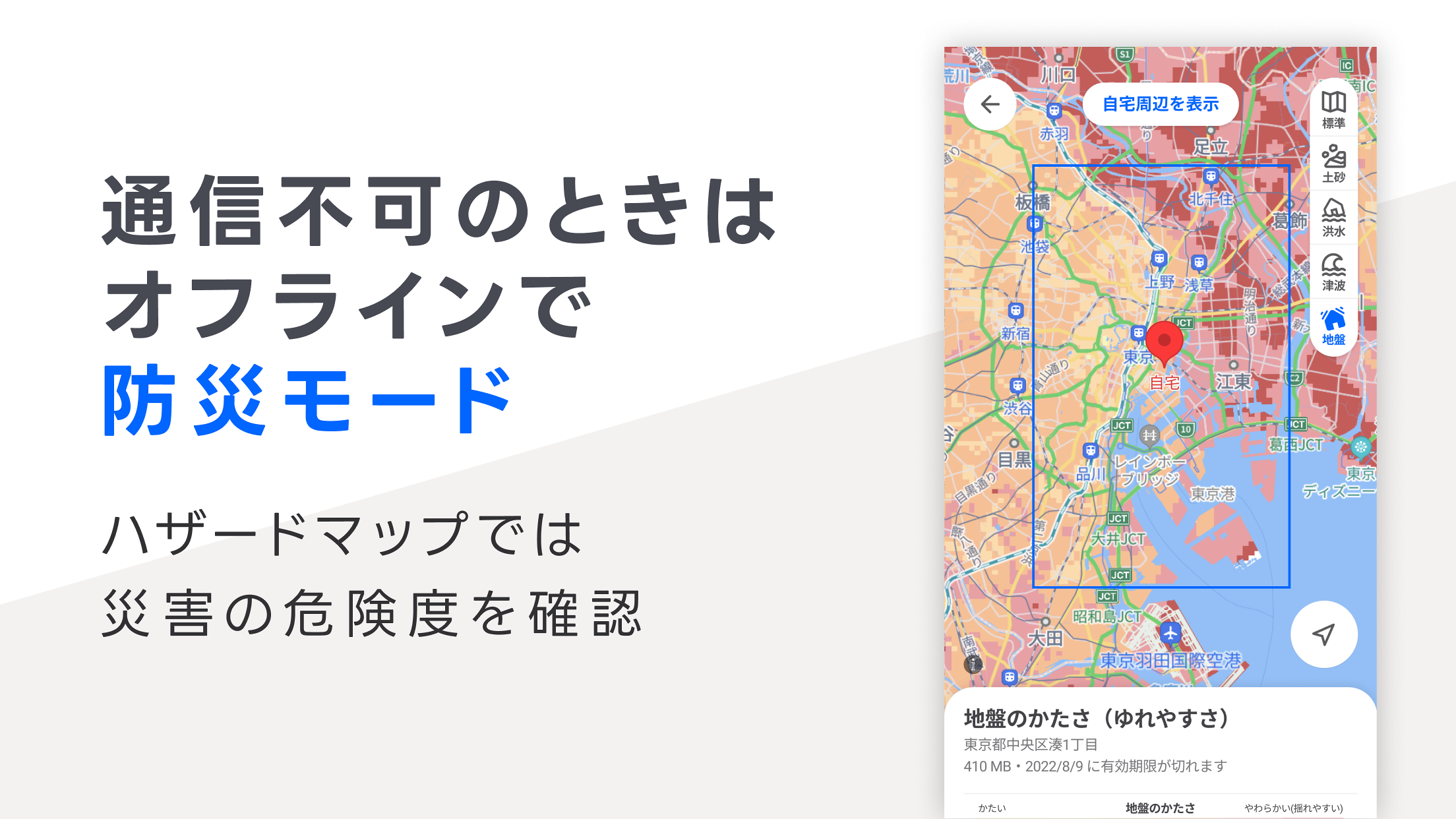
■Disaster prevention mode for disaster preparedness
・Don't worry about communication failures. You can use maps around your home and workplace offline. (Pre-download required)
・Includes a hazard map function that allows you to check information on "landslides," "floods," "tsunamis," and "ground hardness" on the map.
■Other useful features
・Illustrations of famous landmarks.
・Search for "PayPay" to display stores that accept PayPay payments.
・Frequently updated "aerial photographs" taken from artificial satellites.
・"Route maps" color-coded with the line colors of JR, private railways, and subways.
・"Address" maps that show town names, borders, addresses, and even building names.
・Traffic status map showing the real-time congestion of roads.
・Detailed map showing one-way streets.
World map in Japanese.
・Real-time information on coin parking availability.
・Displays current location using GPS.
・Tab function allows multiple screens to be open at the same time.
※1: Yahoo! JAPAN ID login required to use.
※2: Icons indicate approximate locations, not pinpoints of the location.
※3: Information provided by Japan Suspicious Person Information Center (information registered after February 19, 2018)
※4: IndoorAtlas provides indoor geomagnetic positioning.
≪Notes on use≫
■About current location information
Mapbox and our company will obtain your location information in this app and use it in accordance with their respective privacy policies.
・Mapbox Privacy Policy (https://www.mapbox.com/legal/privacy/)
・LINE Yahoo Japan Corporation Privacy Policy (https://www.lycorp.co.jp/ja/company/privacypolicy/)
■Indoor location information
IndoorAtlas and our company will obtain your location information to display indoor location information and use it in accordance with each company's privacy policy.
・IndoorAtlas Privacy Policy (https://www.indooratlas.com/privacy-policy-jp/)
・LINE Yahoo Japan Corporation Privacy Policy (https://www.lycorp.co.jp/ja/company/privacypolicy/)
Operating environment>
Android 8.0 or higher
*This application may not work properly on some models.
Please read the LINE Yahoo Japan Common Terms of Use (including privacy policy and software guidelines) before using this application.
・LINE Yahoo! Common Terms of Use (https://www.lycorp.co.jp/ja/company/terms/)
・Special terms regarding usage environment information (https://location.yahoo.co.jp/mobile-signal/map/terms.html)
・Privacy Policy (https://www.lycorp.co.jp/ja/company/privacypolicy/)
・Software Guidelines (https://www.lycorp.co.jp/ja/company/terms/#anc2)
≪Caution≫
Raincloud radar notification and route guidance functions use GPS in the background, so they may consume more battery power than usual.
Y!マップ 8.69.0 Update
いつもご利用いただき、ありがとうございます。
今回は操作性・安定性向上のための改善を行いました。
Yahoo!マップではご意見フォームを用意しています。みなさまの声を気軽にお寄せください。
アプリ内の[マイページ]>[ご意見・ご要望]から回答できます。
引き続き、Yahoo!マップをよろしくお願いいたします。
Read More