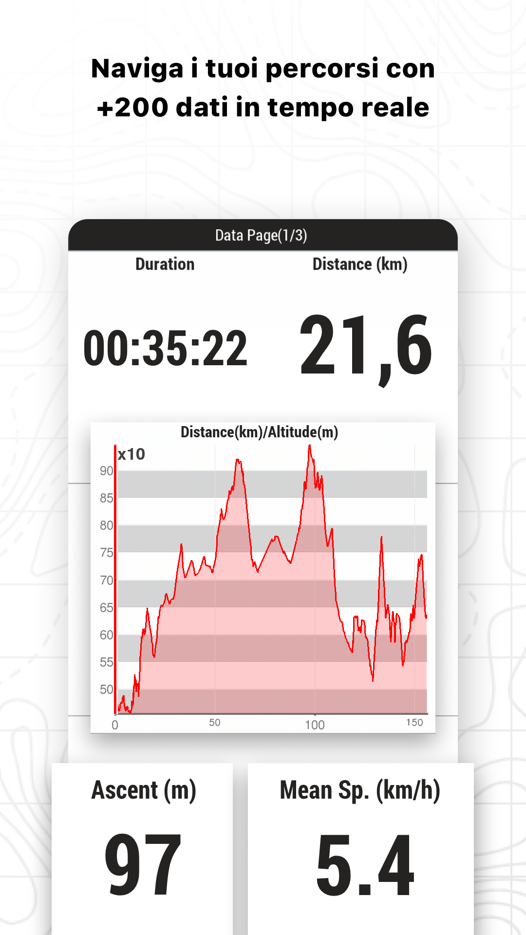
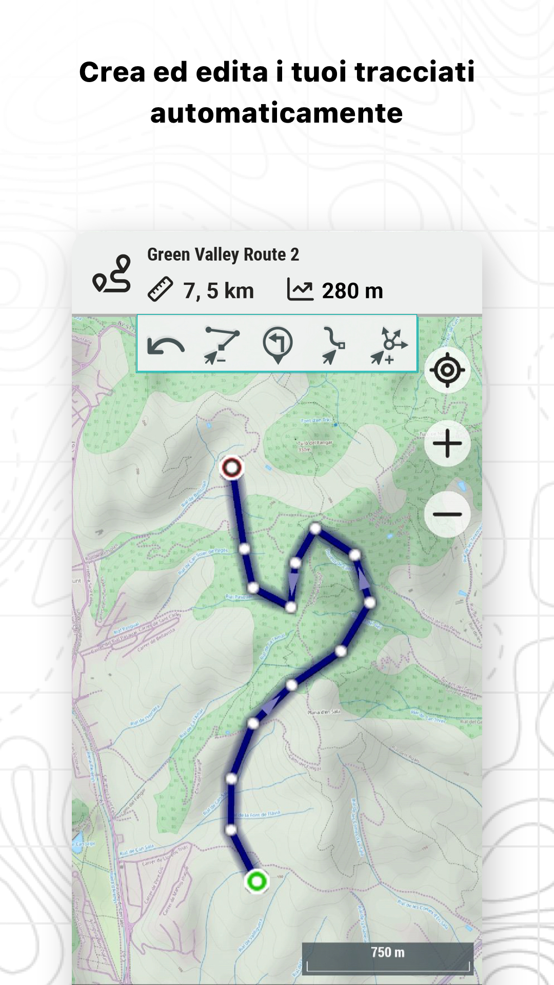
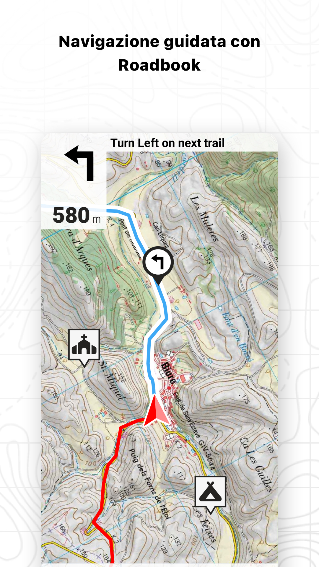
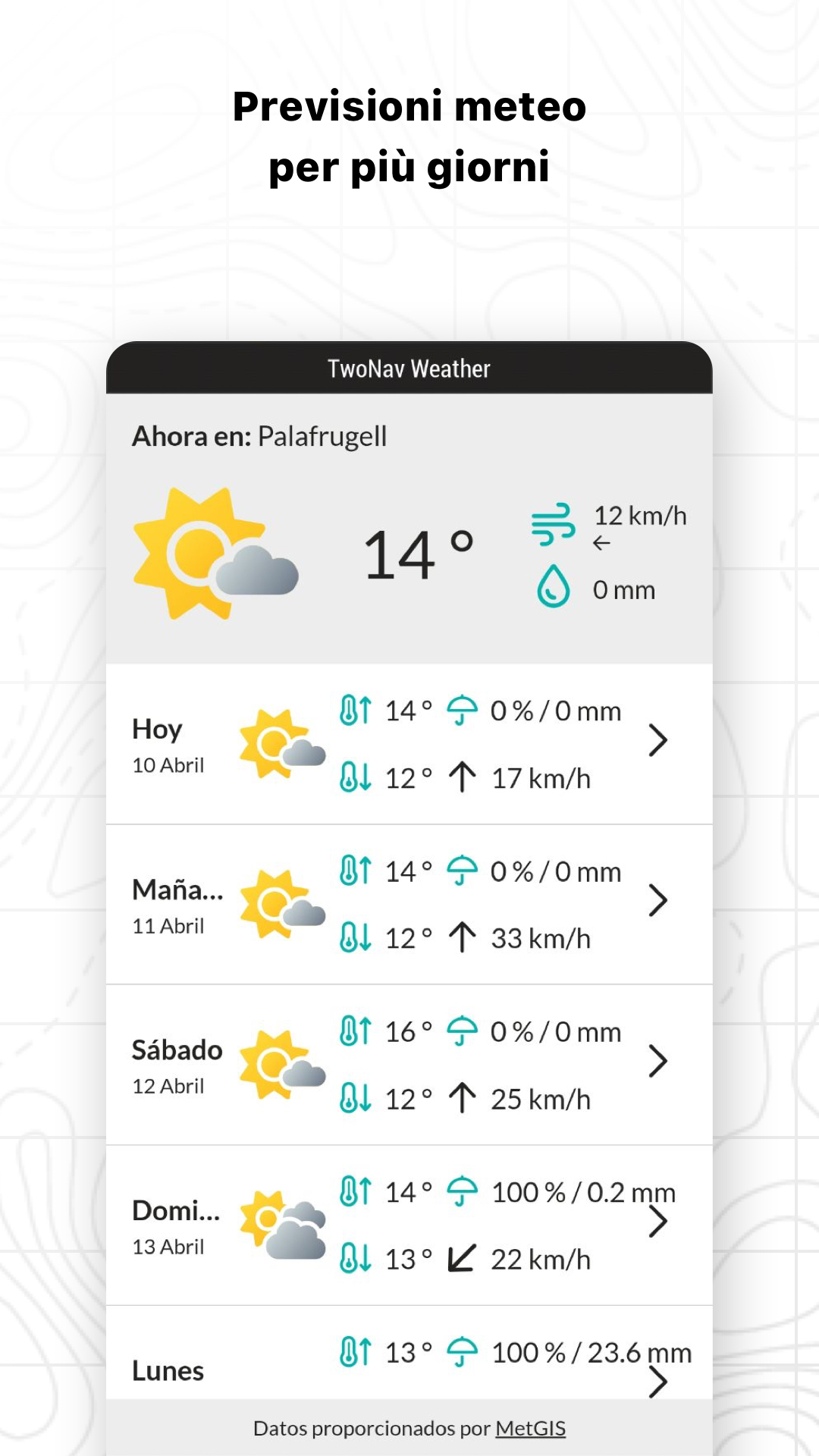
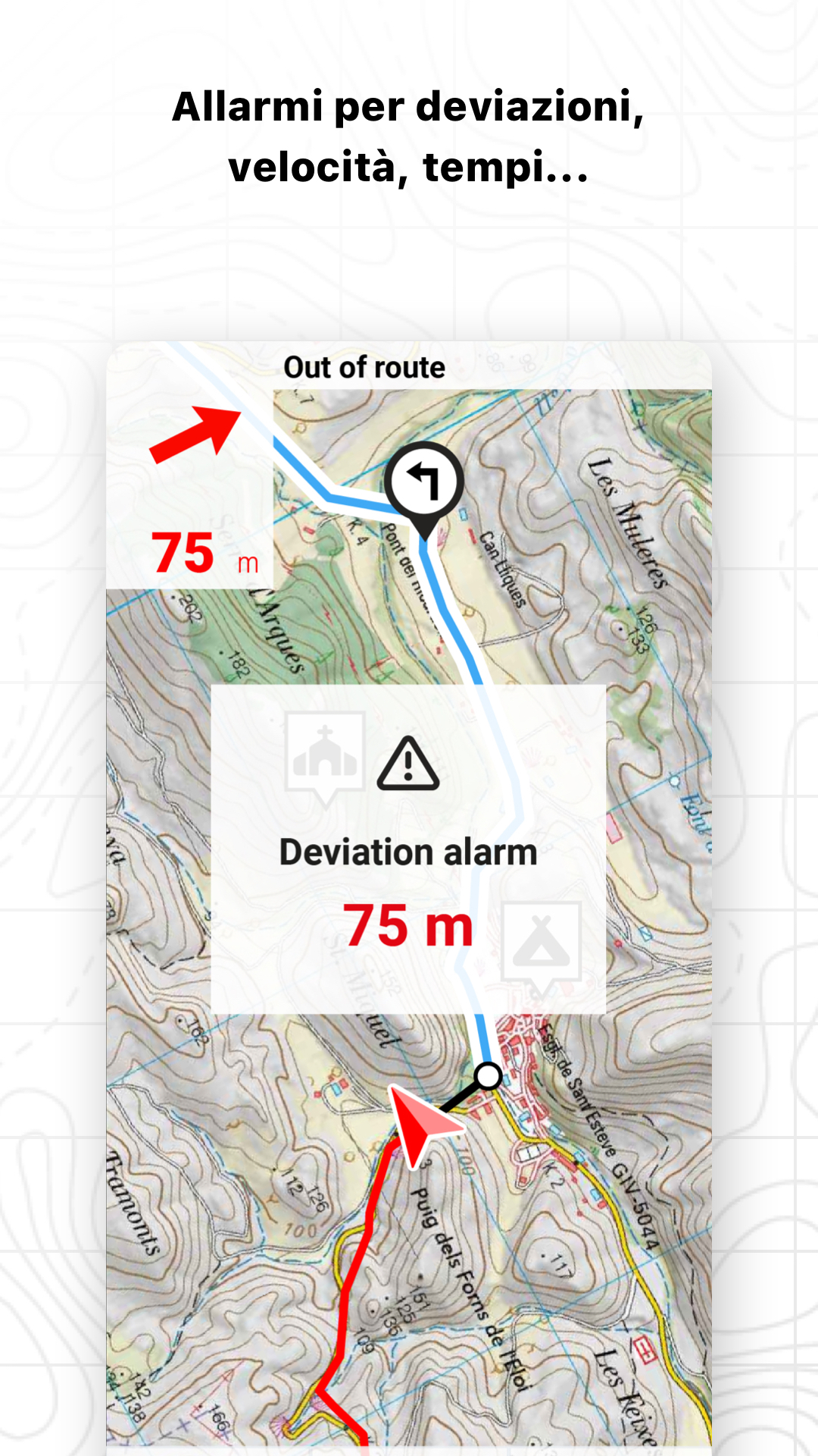
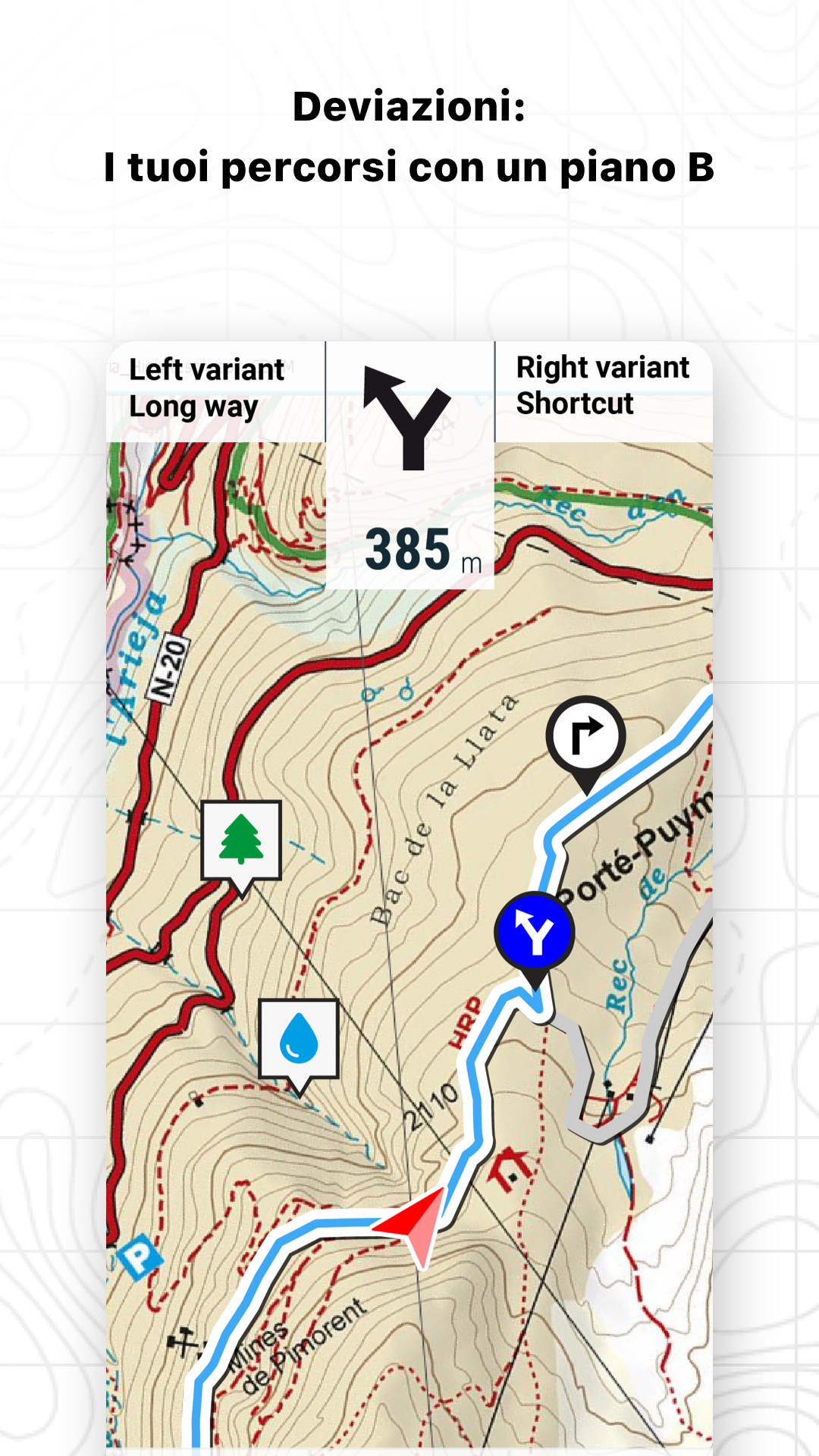
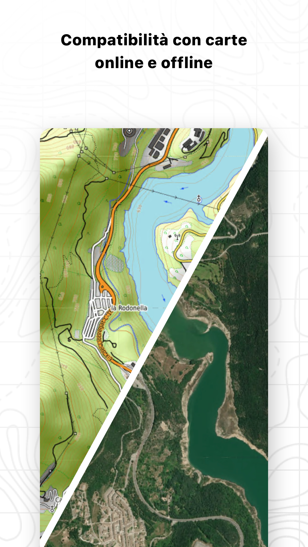
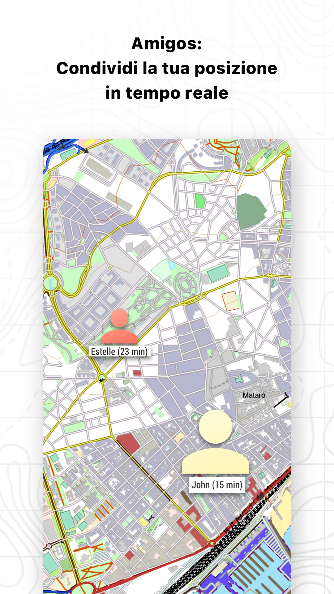
TRASFORMA IL TUO SMARTPHONE IN UN POTENTE SISTEMA DI NAVIGAZIONE Esplora l’ambiente circostante con le migliori mappe, percorri i percorsi più spettacolari, migliora le tue prestazioni e, soprattutto, pratica le tue attività all’aperto in totale sicurezza. Porta le tue uscite a un livello superiore. _______________________ ADATTA L’APP AL TUO SPORT TwoNav si adatta a diversi sport come escursionismo, ciclismo, motori, volo, sport acquatici... Crea il tuo profilo e l’app adatterà la configurazione in base a quello sport. Pratichi altri sport? Crea profili diversi così l’app si adatta alle necessità di ogni momento. _______________________ NAVIGA IN SICUREZZA Segui il tuo percorso controllando la distanza, il tempo e la salita per raggiungere il tuo obiettivo. Naviga su percorsi creati da te, scaricati o calcolati automaticamente. L’app ti avviserà se ti allontani o se ti imbatti in un imprevisto. _______________________ NAVIGAZIONE GPS SEMPLICE E INTUITIVA Dimentica le vecchie annotazioni su carta. Il tuo roadbook ora è digitale, tutto quello che devi sapere è sullo schermo del tuo smartphone. L’app ti indicherà passo dopo passo quale strada seguire. _______________________ STRUMENTI PER L’ALLENAMENTO Decidi se allenarti per tempo, distanza… o se competere con te stesso tramite TrackAttack™. Migliora le prestazioni di un allenamento precedente, l’app ti dirà se stai migliorando o se devi fare di più. _______________________ CREA I TUOI PERCORSI E WAYPOINT Crea percorsi e waypoint toccando direttamente sullo schermo, organizzali in cartelle e collezioni. Inoltre, puoi arricchire i tuoi riferimenti aggiungendo foto e video. _______________________ OTTIMIZZA LE TUE PRESTAZIONI Monitora sempre i dati chiave della tua attività, come distanze, velocità, tempi e altitudini, sia ciò che hai già percorso che quello che ti resta da fare. _______________________ ALLARMI VISIBILI E ACUSTICI Imposta fino a dove vuoi arrivare, programma gli allarmi per farti avvisare quando superi i limiti che hai fissato (battito cardiaco, velocità, altezza, deviazione dal percorso...). _______________________ TRASMETTI LA TUA POSIZIONE IN TEMPO REALE Con l’esclusiva funzione Amigos™ puoi condividere la tua posizione in tempo reale ovunque tu sia. Così garantirai la tua sicurezza e quella dei tuoi cari. _______________________ ANALISI DETTAGLIATA DEI TUOI PERCORSI Tornato a casa, analizza i tuoi itinerari con il massimo dettaglio e precisione. Rivivi ogni tappa delle tue avventure con grafici, sezioni e oltre 120 campi di dati... _______________________ CONNETTITI CON IL MONDO La connessione al Cloud GO (30 MB gratuiti) ti permetterà di conservare tutte le tue attività in un luogo sicuro e accessibile da qualsiasi parte. Connettiti anche ad altri servizi come Strava, TrainingPeaks, Komoot, UtagawaVTT o OpenRunner, sincronizza le tue attività o scarica i tuoi percorsi migliori. _______________________ PREVISIONI METEO Ricevi report meteo da qualsiasi parte del mondo per i prossimi giorni e per fascia oraria. Controlla dati come temperatura, nuvolosità, pioggia, neve e probabilità di temporali. _______________________ ALZA IL LIVELLO DELLE TUE USCITE Non accontentarti della versione GRATUITA dell’app TwoNav, scopri i piani di abbonamento e accedi alle funzionalità avanzate secondo le tue necessità: - MOBILE: Crea i tuoi percorsi nell’app TwoNav con strumenti semplici. Controlla la distanza rimanente. Ricevi avvisi di deviazione e trova sempre la strada di ritorno. - PREMIUM: Crea i migliori percorsi automaticamente nell’app e aggiungi Land sul tuo computer. Consulta le previsioni meteo. Scarica mappe dettagliate da tutto il mondo. Goditi la vista 3D. - - PRO: Crea le tue mappe personalizzate in Land. Apri mappe di altre fonti in formati speciali. Consulta mappe meteo con l’evoluzione per i prossimi giorni.
Aggiornamento TwoNav 6.1.1
Fixed an issue with internet recovery when the data connection was lost. Fixed the first launch showing a far zoomed-out view.
- SeeMe function - Improved adjustment of online map layers for better speed and readability. - Improvement of the processes for scanning and opening track files. - Optimization of synchronization process with GO Cloud - New feature ‘Import nearby waypoints as roadbook points’ in Track Tools. - Suunto connection available in ‘Routes > My Online Routes’ - X symbol to close files in lists - Improved compass design - Other minor changes
- SeeMe function - Improved adjustment of online map layers for better speed and readability. - Improvement of the processes for scanning and opening track files. - Optimization of synchronization process with GO Cloud - New feature ‘Import nearby waypoints as roadbook points’ in Track Tools. - Suunto connection available in ‘Routes > My Online Routes’ - X symbol to close files in lists - Improved compass design - Other minor changes
- SeeMe function - Improved adjustment of online map layers for better speed and readability. - Improvement of the processes for scanning and opening track files. - Optimization of synchronization process with GO Cloud - New feature ‘Import nearby waypoints as roadbook points’ in Track Tools. - Suunto connection available in ‘Routes > My Online Routes’ - X symbol to close files in lists - Improved compass design - Other minor changes
- SeeMe function - Improved adjustment of online map layers for better speed and readability. - Improvement of the processes for scanning and opening track files. - Optimization of synchronization process with GO Cloud - New feature ‘Import nearby waypoints as roadbook points’ in Track Tools. - Suunto connection available in ‘Routes > My Online Routes’ - X symbol to close files in lists - Improved compass design - Other minor changes
- Aesthetic improvements - New subscription system (previous license holders retain their functionality) - New track editor with FastTrack, Draw track, Add roadbook point, Delete track point, Undo/Redo - Weather forecast - Improved 'Toggle maps' tool - Faster online maps - Plus Maps - Compatibility with MPV, GPKG, MBTiles, TIF (COG), and ECW maps - New map store - New 'Restore purchases' feature that adds in-app purchases to myTwoNav - Other minor changes
- Aesthetic improvements - New subscription system (previous license holders retain their functionality) - New track editor with FastTrack, Draw track, Add roadbook point, Delete track point, Undo/Redo - Weather forecast - Improved 'Toggle maps' tool - Faster online maps - Plus Maps - Compatibility with MPV, GPKG, MBTiles, TIF (COG), and ECW maps - New map store - New 'Restore purchases' feature that adds in-app purchases to myTwoNav - Other minor changes
- Aesthetic improvements - New subscription system (previous license holders retain their functionality) - New track editor with FastTrack, Draw track, Add roadbook point, Delete track point, Undo/Redo - Weather forecast - Improved 'Toggle maps' tool - Faster online maps - Plus Maps - Compatibility with MPV, GPKG, MBTiles, TIF (COG), and ECW maps - New map store - New 'Restore purchases' feature that adds in-app purchases to myTwoNav - Other minor changes
- Aesthetic improvements - New subscription system (previous license holders retain their functionality) - New track editor with FastTrack, Draw track, Add roadbook point, Delete track point, Undo/Redo - Weather forecast - Improved 'Toggle maps' tool - Faster online maps - Plus Maps - Compatibility with MPV, GPKG, MBTiles, TIF (COG), and ECW maps - New map store - New 'Restore purchases' feature that adds in-app purchases to myTwoNav - Other minor changes
APKFab.com e il link per il download di questa app sono sicuri al 100%. Tutti i link per il download delle app elencate su APKFab.com provengono da Google Play Store o sono inviati dagli utenti. Per le app da Google Play Store, APKFab.com non le modificherà in alcun modo. Per le app inviate dagli utenti, APKFab.com verificherà la sicurezza della firma APK prima di rilasciarle sul nostro sito web.