海釣図V (Package Name: jp.mappleon.kaichouzutile2) is developed by Mapple ON Co., Ltd. and the latest version of 海釣図V~海釣りマップ&潮汐&風・波・海水温予報~ 2.1.0 was updated on October 29, 2023. 海釣図V~海釣りマップ&潮汐&風・波・海水温予報~ is in the category of Sports. You can check all apps from the developer of 海釣図V~海釣りマップ&潮汐&風・波・海水温予報~ and find 6 alternative apps to 海釣図V~海釣りマップ&潮汐&風・波・海水温予報~ on Android. Currently this app is for free. This app can be downloaded on Android 10.0+ on APKFab or Google Play. All APK/XAPK files on APKFab.com are original and 100% safe with fast download.
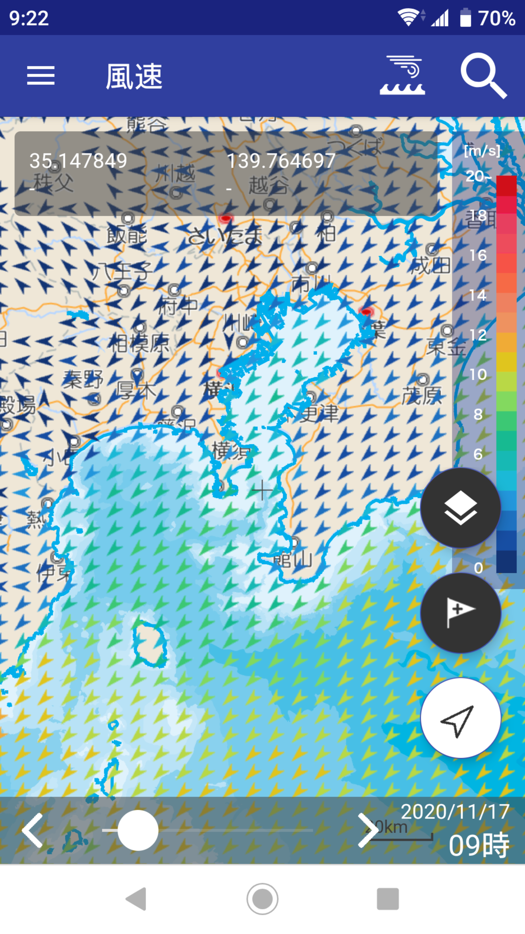
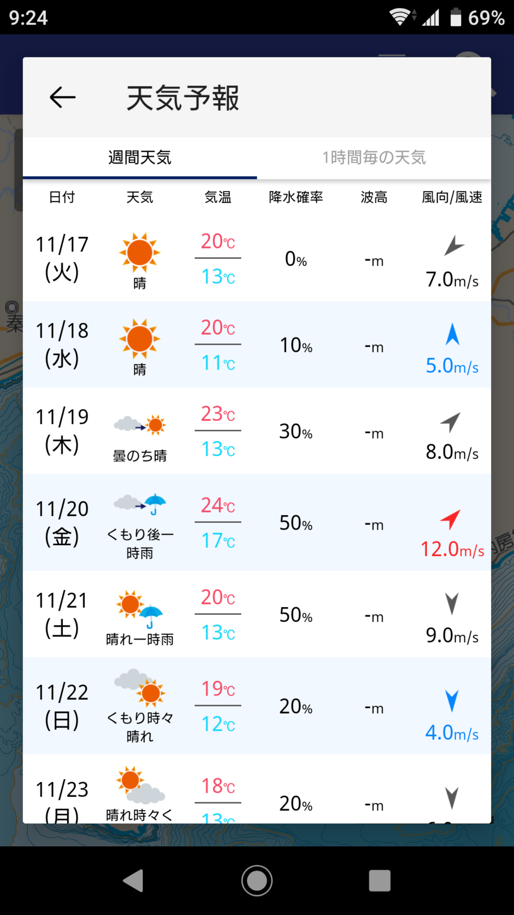
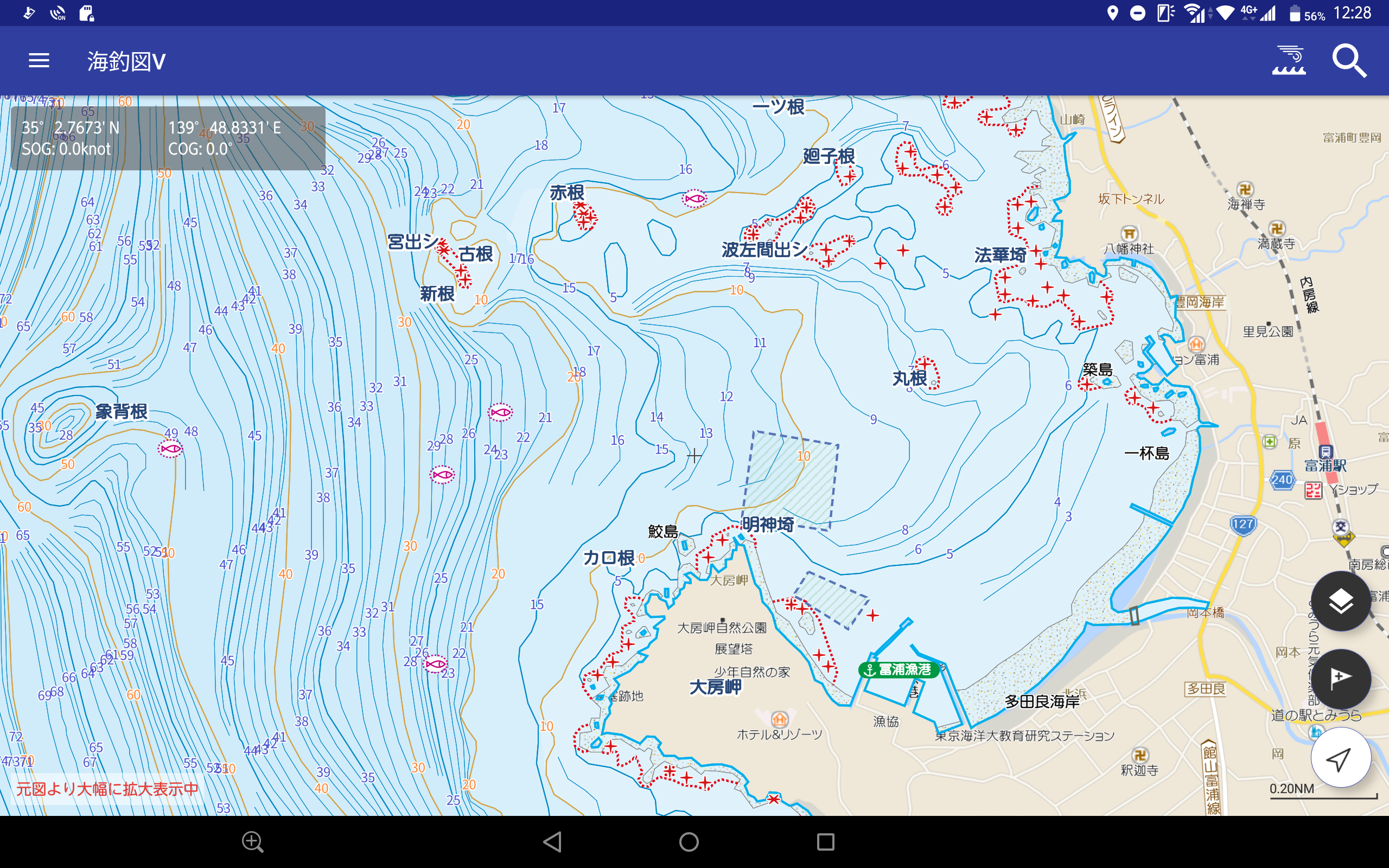
The sea fishing map app "Sea Fishing Chart" has been renewed! ! 【please note】 "Sea fishing chart V" is for Android 8.0, GPS-equipped models with RAM 3GB or more. ・On devices with less than 3GB of RAM, operation may be slow or may not work properly. ・Please use a terminal equipped with a GPS sensor (capable of acquiring location information from GPS satellites). The app cannot be launched on non-equipped devices. ・Ver.1.4.1 is the final version for devices with Android 7.x or lower. ■ What kind of app is "Sea Fishing Chart V"? "Sea fishing chart V" is the successor version of the sea fishing map app "Sea fishing chart" that uses part of the data of "Electronic reference map for navigation new pec (provided by Japan Hydrographic Association)". This is a sea fishing map app that has been significantly renewed from the previous version of "Sea Fishing Chart", such as greatly expanding the area, making the map seamless, and improving operability. ■ The big difference between "Sea Fishing Chart V" and "Sea Fishing Chart"! ○ The service area has expanded significantly throughout Japan! ・ Covers the area where “new pec” is provided ○ Seamless and crisp operation is possible! ・Nationwide seamless and crisp operation ・Easy operation by swiping, pinching in and pinching out ○ Fully compatible with "new pec" updates (4 times a year)! ・Supports updates and releases of "new pec" released four times a year (*) earlier than anywhere else ・Update period: January, April, July, October ・Other urgent updates will be implemented in a timely manner. ■ Main features and functions ○ Sea fishing map that uses some data from "new pec" ・Color-coded display for easy viewing of detailed contour lines ・Displays the location of "fish reef" and "root" that are points for fishing ・The “fishing port” where recreational fishing boats and rental boats depart is also displayed. ・Includes "marina" and "sea station", which are convenient for stopping by pleasure boats. ・Displays "dark rocks, washed rocks, dry rocks" that may run aground during navigation ★ To use the "detailed map", you need to purchase a regular monthly ticket. ○ Bakutsuri points are "My point registration" ・ Easily register points with good fishing results in My Points ・You can easily register your own fishing points that are not on the map on the spot. ・Share my points with your fishing buddies (share by email) ○ Manage fishing records (GPS logs)! ・Save the wake (GPS log) when you go fishing with a boat or kayak ・The fishing record details page also displays photos of the day of fishing, making it useful as a fishing diary. ・Share saved fishing records with friends (share by email) ○ "Backup function" for peace of mind! ・My points and fishing records can be backed up. ・Reliable design even in case of model change or terminal trouble ○ Equipped with weather and sea condition information unique to smartphone apps ・Displays wind speed/direction/prediction data ・Displays actual/predicted data on wave height, wave direction, and wave cycle ・Displays actual/predicted sea surface temperature data ・Pinpoint weather forecast by latitude and longitude of current location and map center point (1-hour forecast/weekly weather) *Please note that if the display area (center point) is over the ocean, part of the weekly weather will not be displayed. ★ To use "Sea Information" and "Weather Forecast", you need to purchase a regular monthly ticket. ■ Regular subscription fee 500 yen per month (tax included) You can try the first registration for free for 30 days. *After the free period expires, you will be charged automatically, but if you "cancel" within the free period, you will not be charged. *Subscription fees are subject to change, so please be sure to check the purchase screen before registering. ■ Compatible OS and models ・This application is compatible with Android 8.0, GPS-equipped models with RAM 3GB or more. * Please note that models other than the above compatible models (Android 7.x or lower, models without GPS, etc.) are not supported. * Even with Android 8.0 or higher, it may not work properly on older models. * Android-based customized OS such as Fire OS and Chrome OS are not supported. *The app cannot be started on models without GPS. *Please note that GPS performance varies greatly depending on the model, OS, etc. Since many manufacturers have released various models of Android devices, it is not possible to check the operation of all models. Even if it is the target spec, it may not work properly. In particular, we may not be able to confirm the specifications of tablets made overseas, so please be aware that we cannot respond to problems that occur. ■ Notes ・This app is not a nautical chart, so please do not use it for navigation. ・Please use in accordance with the actual laws and regulations and the rules of the surrounding fisheries cooperatives. ・Please pay sufficient attention to safety, such as the weather, sea conditions, and surrounding conditions. ・Because this application consumes a lot of battery, please be sure to bring a spare battery etc. ・We are not responsible for any trouble, accident, distress, etc. caused by using this application. * When using online, the latest files such as maps will be obtained as necessary, so if you want to reduce the amount of communication, please download the map in advance in a WiFi environment and use it offline.
APKFab.com and the download link of this app are 100% safe. All download links of apps listed on APKFab.com are from Google Play Store or submitted by users. For the app from Google Play Store, APKFab.com won't modify it in any way. For the app submitted by users, APKFab.com will verify its APK signature safety before release it on our website.