About トラックカーナビ
トラックカーナビ (Package Name: com.navitime.local.navitimetruck) is developed by NAVITIME JAPAN CO., LTD. and the latest version of トラックカーナビ - 大型車規制に対応 by ナビタイム 9.3.0 was updated on December 18, 2025. トラックカーナビ - 大型車規制に対応 by ナビタイム is in the category of Maps & Navigation. You can check all apps from the developer of トラックカーナビ - 大型車規制に対応 by ナビタイム and find 42 alternative apps to トラックカーナビ - 大型車規制に対応 by ナビタイム on Android. Currently this app is for free. This app can be downloaded on Android 10.0+ on APKFab or Google Play. All APK/XAPK files on APKFab.com are original and 100% safe with fast download.
A first in Japan!
Truck Navigation App Specialized for Truck DriversTruck Navigation is a fully-fledged car navigation system for smartphones and tablets.
▼Truck Navigation Features
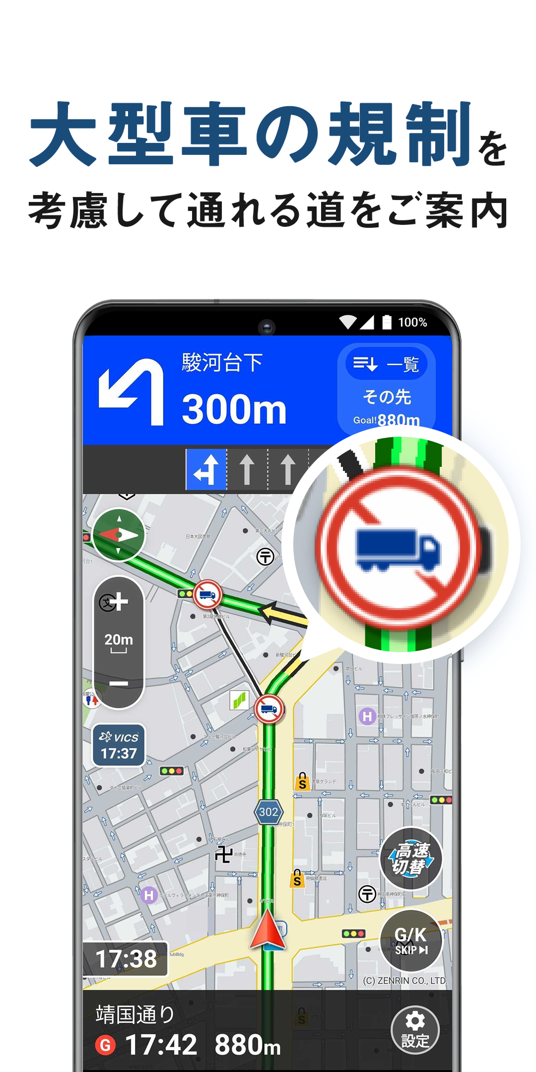
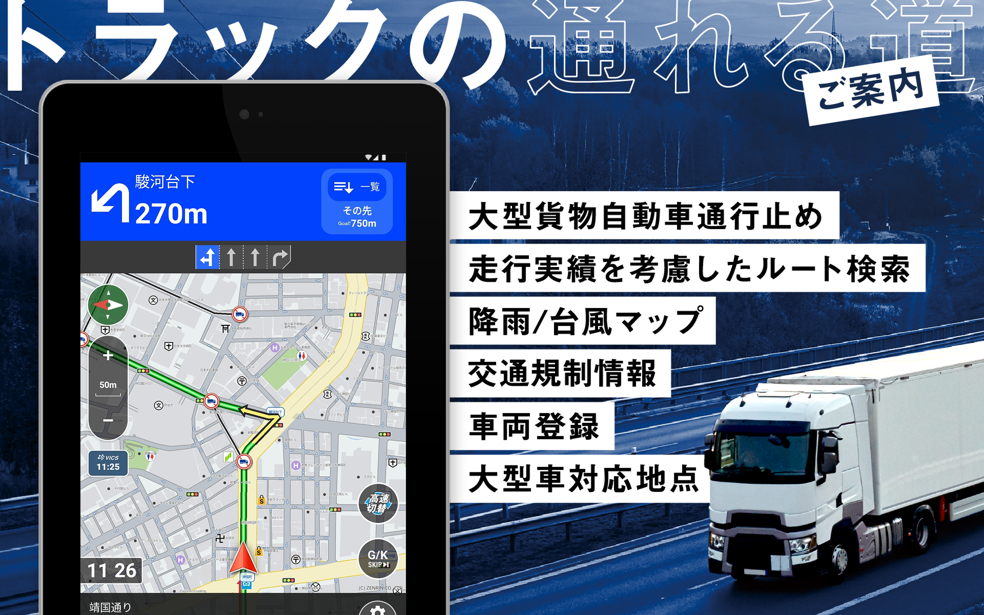
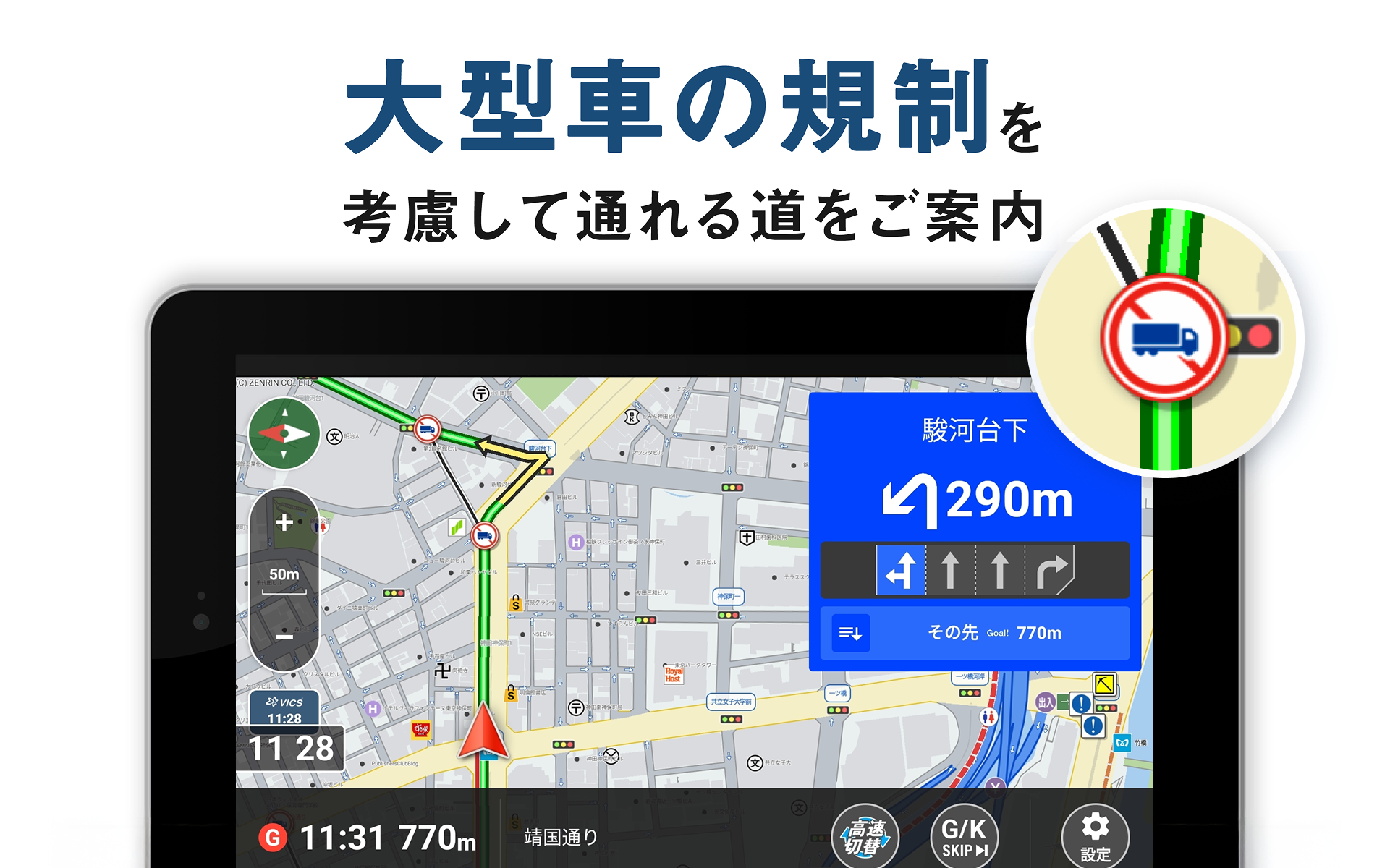
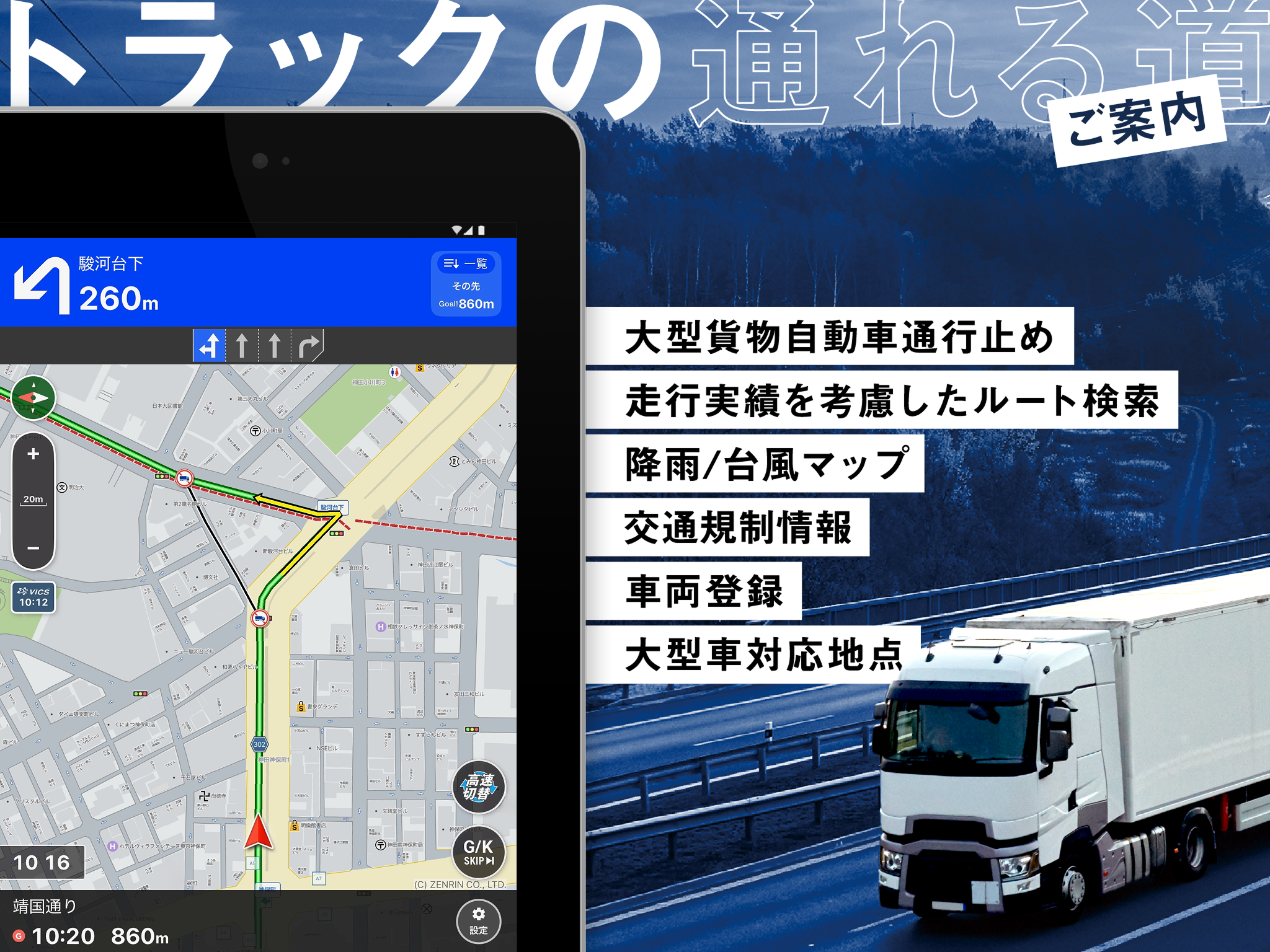
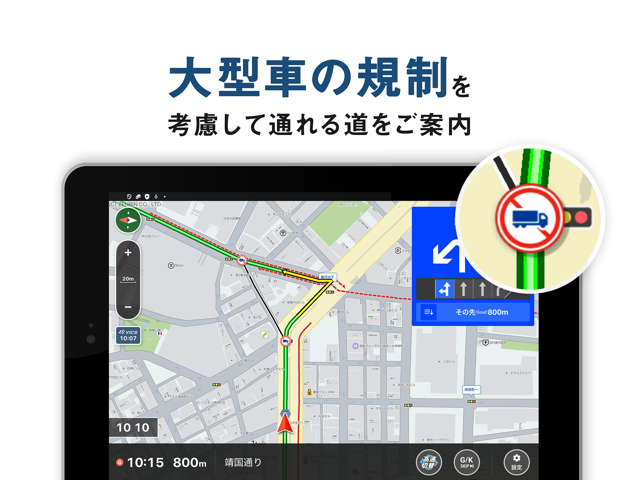
★Complies with nationwide road closure regulations for large freight vehicles, etc.
Includes approximately 106,000 locations
★Complies with nationwide vehicle restrictions for height, width, and weight
Includes approximately 86,000 locations
★Compatible with the latest Zenrin Maps
Free automatic updates
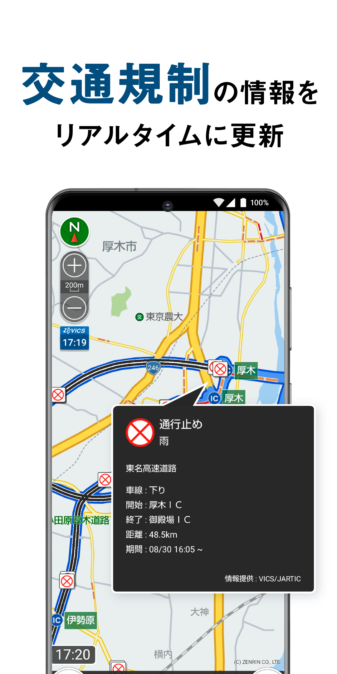
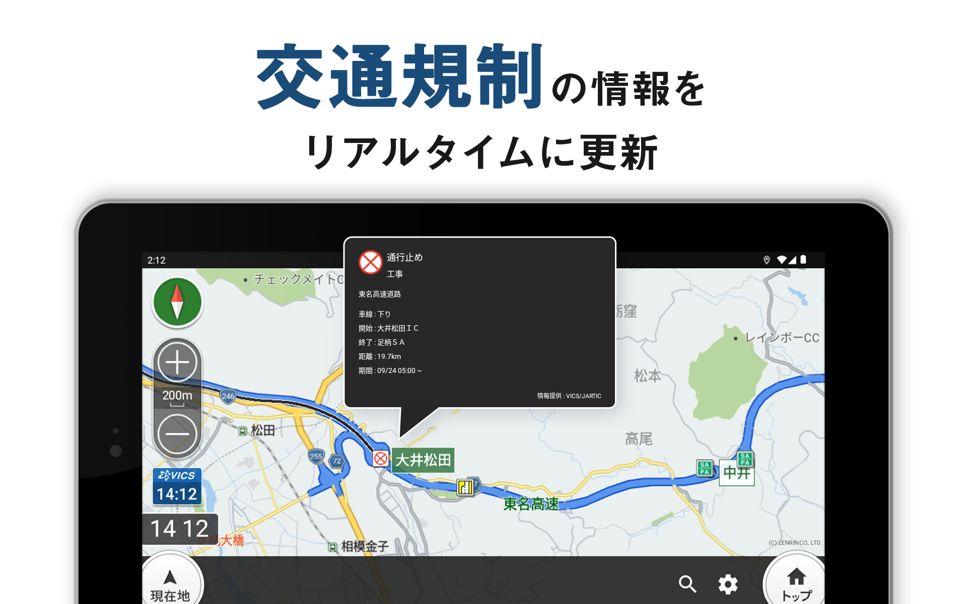
★Real-time updates of nationwide traffic and congestion information
Uses information distributed by the VICS Center and the Japan Road Traffic Information Center (JARTIC) as well as probe information.
※What is probe information? ─This is Navitime's proprietary traffic information, generated through statistical analysis of driving logs from Navitime's car navigation app. Data volume is 16 million km per day, roughly equivalent to circling the Earth 400 times! *Actual results from July to September 2025
★Compatible with Truck Entrances
Supports route guidance to truck entrances at factories and logistics facilities.
▼Truck Navigation is a NaviTime app
・Evolved from a Drive Supporter app to a truck-specific app.
・Utilizing the know-how cultivated through NaviTime, we pursued an operation experience optimized for logistics transport.
・Features for truck drivers and various data for freight vehicles.
・Navigation is provided on safe and secure roads that are easy for trucks to navigate.
・Utilizes probe information from NaviTime's various car navigation apps to achieve highly accurate estimated arrival times.
Payment Plans and Features■Free Plan
Packed with features, even for free!
・Location search compatible with large vehicles
・Street View integration (launches Google Maps)
・Automatic updates to Zenrin maps and location information
- Instant response to major road openings
- Map display of ETC-only toll booths
・Aerial satellite imagery map mode
・Weather information map
- Precipitation/snow radar, typhoon forecast, snow depth map
・Map icon display
- Convenience stores, gas stations, roadside stations, etc.
・Accident location map
- Map display of nationwide accident locations by vehicle type
・Rest area map
- Locations accessible to trucks collected by all drivers
・Route search taking into account roads accessible to large vehicles
- Simultaneous search of up to 20 destinations
- Destination setting for left-side access
- Internal speed setting
- ETC/Smart IC usage, etc.
・Route search specifying highway entrances and exits
- Expressway Toll Comparison
・Route search to avoid heavy rainfall
・Route search that takes into account truck entrances and loading docks
・Route search that takes into account entrances and exits where right turns are prohibited at logistics facilities (GLP)
・Navitime Mileage
- Mileage points!
And many more
■Premium Course
[¥840/month, ¥7,800/year]
All basic features available
・Road Restrictions Display
- Road closures for large freight vehicles
- Vehicle class restrictions
- Prohibition on travel in any other direction
- VICS Restrictions/Traffic Information
*VICS includes JARTIC road traffic information. JARTIC's data includes information from urban expressways operated by NEXCO East Japan, NEXCO Central Japan, NEXCO West Japan, and the Metropolitan Expressway.
・Live cameras
- View road and port congestion status
・Distorted traffic congestion maps
- Real-time road traffic information from VICS/JARTIC
- Nationwide highway restriction/congestion section information
- Supports chain restriction sections
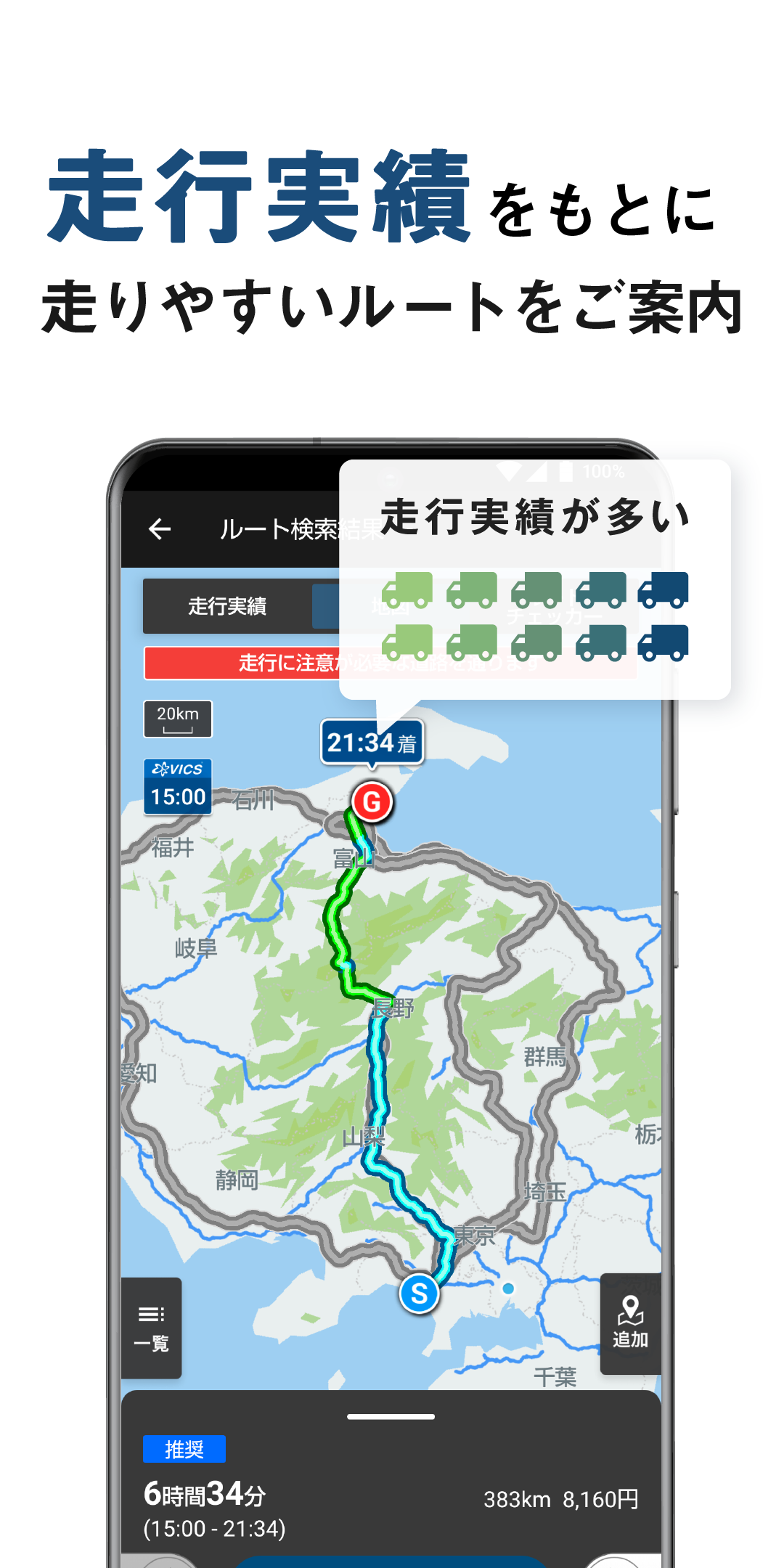
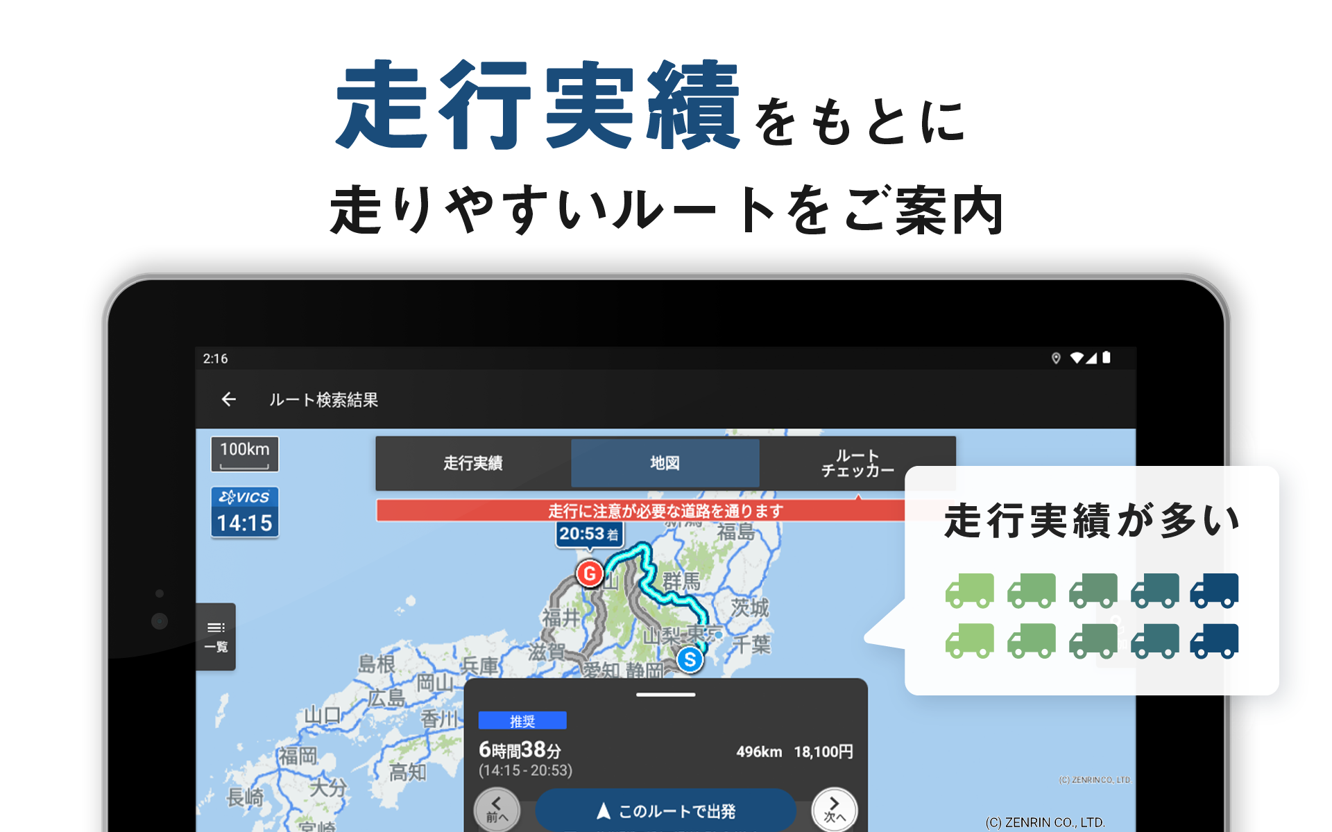
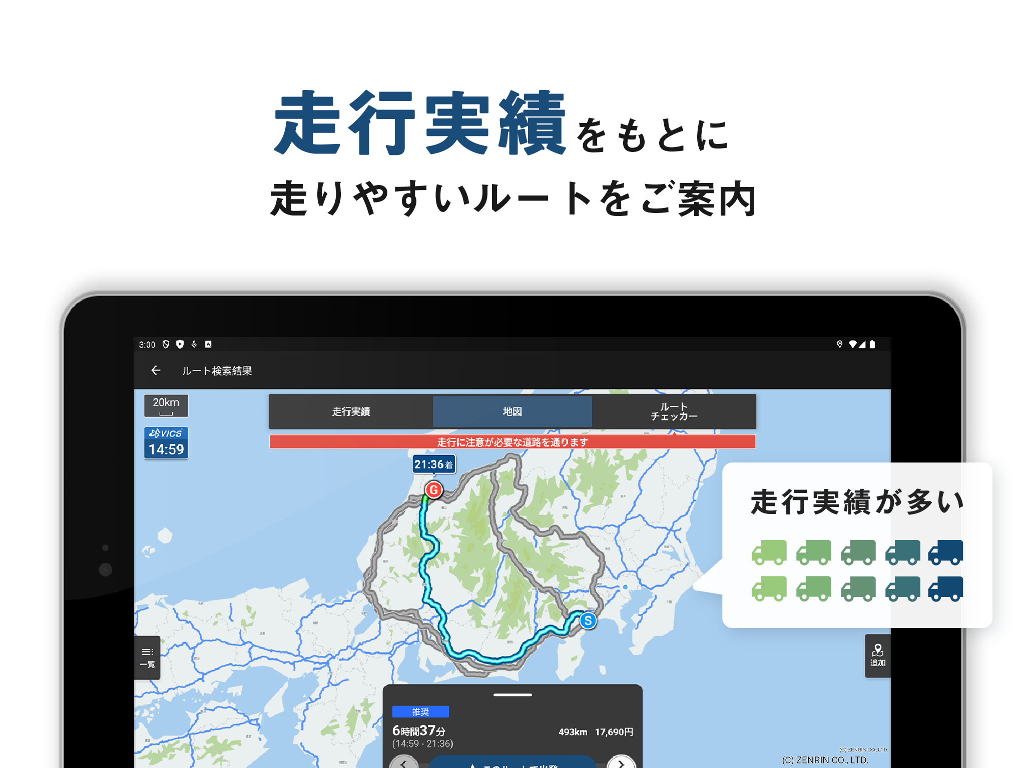
・Map display of driving history
- Driving history for each road section by vehicle class
・Enhanced route search
- Considers traffic congestion information
- Considers hazardous material loading restrictions
- Up to 8 route suggestions
・Safe and secure voice guidance (navigation)
- Road width, height, and road closure information
- Cautionary notifications for warnings and advisories issued along the route
- Background navigation function
・Comprehensive navigation features
- Displays SA/PA parking lot availability information (for large vehicles)
- Displays the speed limit for your current location
- Real-time rerouting (sudden detour suggestions)
- Conveniently register up to 5 vehicles
- Expressway toll classification settings
- Hazardous materials loading settings
- My Data for mastering the app
- My Locations feature allows you to register your favorite locations
- My Route Plan feature allows you to register a list of destinations (up to 40 destinations)
- Schedule feature suggests pre-registered My Route Plans based on your trip dates (up to 10 destinations)
- Automatically sorts your route plans for efficient route planning with the Route Search feature
- Track Log for reviewing your trip
- Exchange Navitime Mileage points for G Points
And many more
[Special Offer for First-Time Registration]
Try all Premium features for free for one month!
■Premium Plus Course
[¥1,650/month, ¥15,400/year]
For those who want more advanced features
・Unlimited My Location registrations
・Expanded My Route Plan registrations (up to 600)
- Schedule function (up to 300)
・Offline navigation (downloadable maps)
- Voice guidance and map display even when out of range
・Android Auto
- Navigation on the large in-car display
・Real-time track log updates
・Restore route search
- Recreate track log routes! Guides you to passable routes
・Set dwell time for each destination
- Improved arrival time accuracy with traffic congestion forecasts for actual operating hours
Truck Disaster Prevention FunctionWe have released the "Disaster Prevention Handbook," a disaster prevention plan for trucking companies to prepare for emergencies during transportation, such as natural disasters.
https://static.truckapp.navitime.jp/web/disasterprevention?from=android_store
Information provided/sourced by: All Japan Trucking Association, Ishikawa Prefecture Trucking Association "Disaster Prevention Manual," Japan Automobile Federation (JAF), Tokyo Fire Department, Ministry of Land, Infrastructure, Transport and Tourism
Map Settings■Map Icon
Gas Station Brands: ENEOS Wing / Enex Fleet / Nishinippon Fleet / Taiyo Koyu / Kitaseki / ENEOS / Idemitsu Kosan / Showa Shell / Apollo Station / Taiyo Oil (SOLATO) / Cosmo Oil / Usami / Kygnus Oil / JA-SS / Itochu
Convenience Stores: 7-Eleven / FamilyMart / Lawson / Lawson Store 100 / Ministop / Daily Yamazaki / Seico Mart
■3D Vehicle Location Icon
Lineup: Trucks / Crane Trucks / BOSS Trucks / Carrier Trucks / Trailers / Dump Trucks / Tank Trucks / Garbage Trucks / Flatbed Trucks / Snowmobiles / Heavy Equipment Transport Vehicles / Mixer Trucks / Crane Trucks / Tow Trucks / Aerial Work Platforms / Euro-Style Trucks / Pickup Trucks / Lumber Transporters / Other
Notes■Location Information/GPS
- When using a navigation system, be sure to secure it in the vehicle mount to improve location accuracy.
- GPS signals are weak. To increase reception, place it away from the vehicle frame.
- High-accuracy location determination may take longer on MVNO and Wi-Fi devices.
■Compatible Vehicles
- The freight vehicles subject to regulations in this app are standard freight vehicles, semi-medium freight vehicles, medium-sized freight vehicles, and large freight vehicles. Special vehicles (including, but not limited to, those exceeding the general limits set forth in the Road Act and the Vehicle Restrictions Ordinance) and towing vehicles (including, but not limited to, trailers and double-articulated trucks) are not included.
- Some features allow you to create routes based on your specified conditions, but please use these features at your own discretion and responsibility.
- To the extent permitted by law, we assume no responsibility for the use of these features.
■Operating Environment
- The app cannot be installed on devices without GPS. Additionally, the app may not be usable on devices with GPS that cannot receive GPS (QZSS) signals within Japan.
- Navigation requires a large amount of memory (RAM). It cannot be installed on Android Go devices or devices with less than 2GB of RAM. For smooth operation, we recommend using a device with 4GB or more of RAM. *The app runs on the Android OS, but please note that the OS itself constantly uses several GB of memory.
- The app may not function properly if there is insufficient memory available.
- Approximately 5 GB of free storage space is required to download maps for offline navigation. (Data capacity: approximately 3 GB)
トラックカーナビ 9.3.0 Update
★ Ver 9.3.0を公開しました(2025/12/09)
■ 右左折案内の改善
・距離の案内に加えて、「2つ目の信号を右方向です」のような案内を行うように改善しました。
■ 内部処理改善
・内部処理の改善を行いました。
■ その他
ご指摘頂いた点含め、順次改善と不具合等の改修を行っております。
Read More