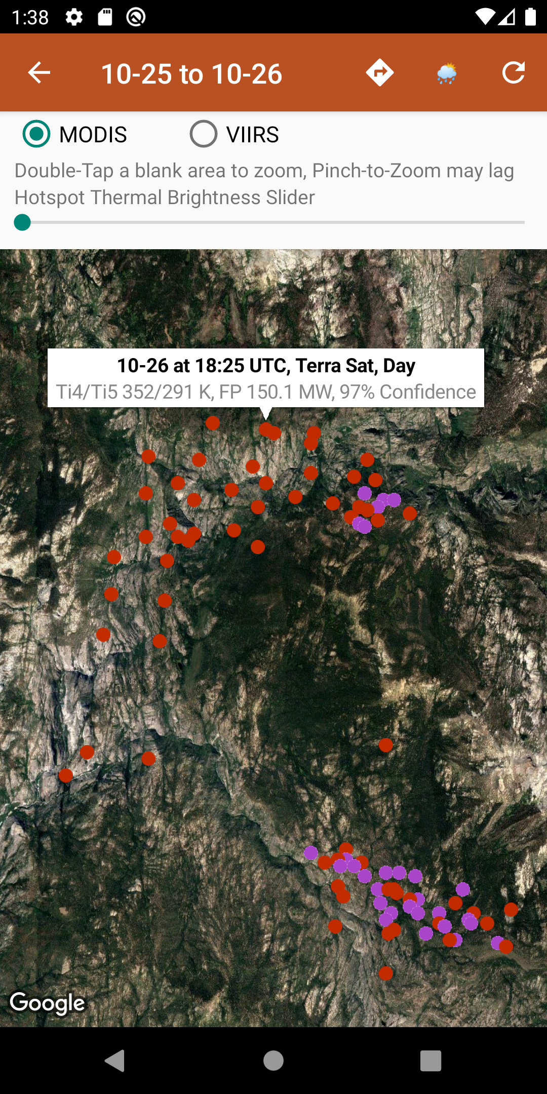
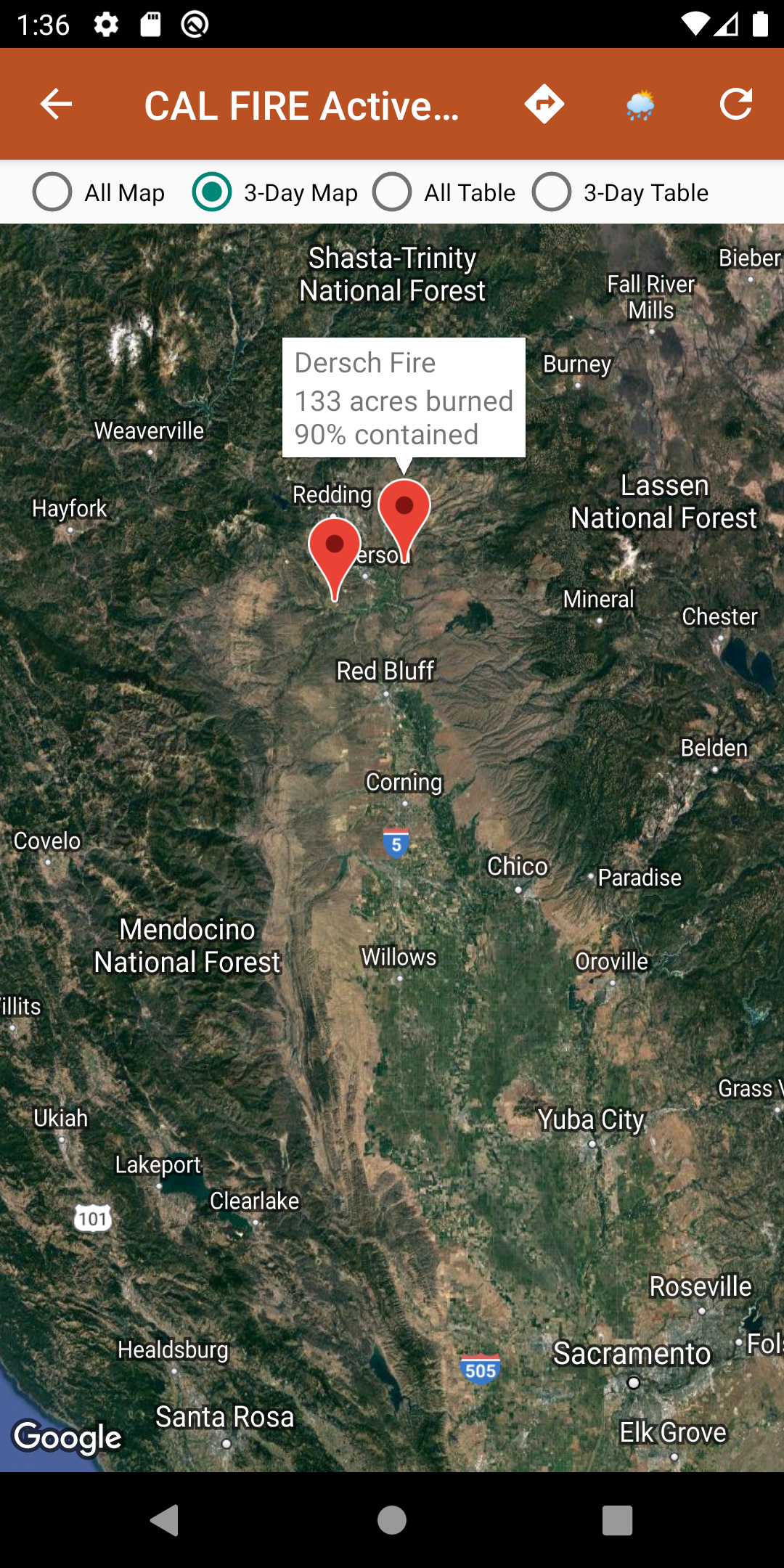
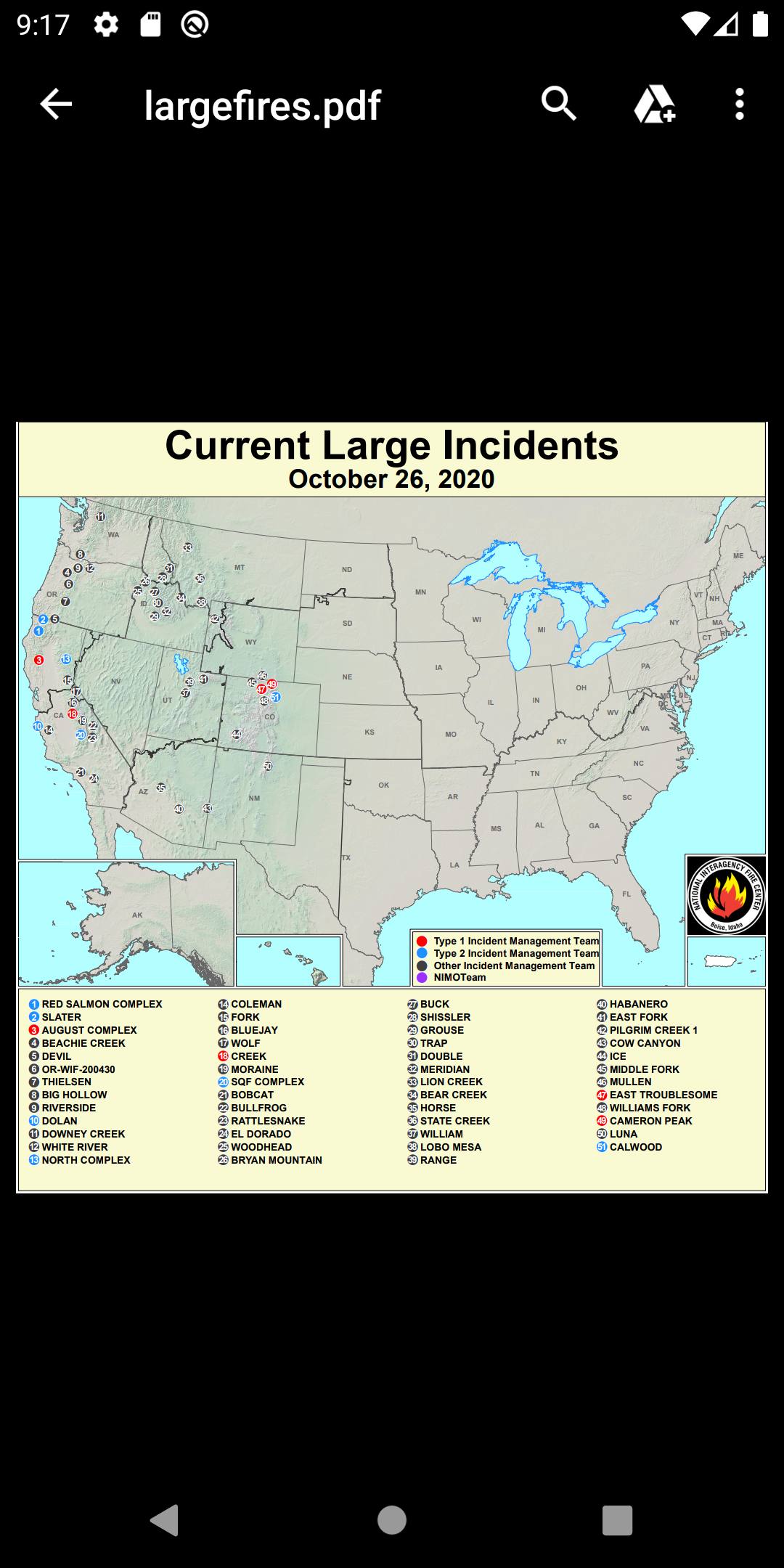
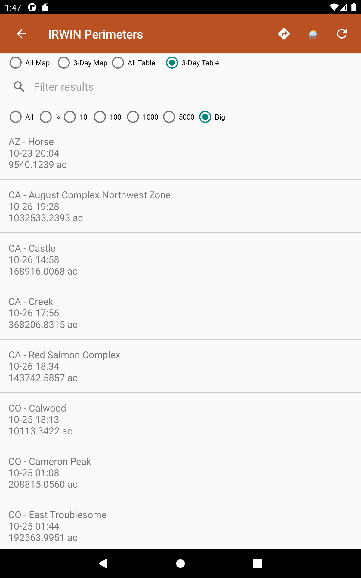
Wildfire Info

7.9 16

v3.0 by David Gross Apps

Wildfire Info APK 下載 Wildfire Info APK 下載
通過APKFab客戶端下載
安全快速安裝 - 無區域限制

關於 Wildfire Info

Wildfire Info(包名:com.davidgrossapps.wildfire)開發者是David Gross Apps,Wildfire Info的最新版本3.0更新時間為2022年05月12日。Wildfire Info的分類是天氣。您可以查看Wildfire Info的開發者下的所有應用並找到Wildfire Info在安卓上的200個相似應用。目前這個應用免費。該應用可以從APKFab或Google Play下載到Android 4.4+。APKFab.com的所有APK/XAPK文檔都是原始文檔並且100%安全下載的資源。
免責聲明:這個非官方的應用程序不代表任何政府機構,也不隸屬於任何政府機構。數據來源是下面列出的可公開訪問的來源。
瀏覽世界各地當前的野火和規定的燒傷活動。
來自 WFIGS 的活動野火周界數據每 20 分鐘更新一次。按州標記,按名稱搜索,並按燃燒的英畝數進行過濾。 WFIGS 代表 Wildland Fire Interagency Geospatial Services (WFIGS) Group
NASA MODIS 和 VIIRS 衛星儀器數據:按地區劃分的熱熱點圖顯示過去 48 小時內的野火活動。查看熱點信息,包括火輻射功率、亮度溫度和置信度。
來自 EPA AirNow 和 PurpleAir 的全球空氣質量數據(PM 2.5、PM10 和臭氧)。
InciWeb & CAL FIRE 活動火災地圖:熱鏈接到相應的官方事件網頁。
CHP (California Highway Patrol):過去 3 小時內與火災有關的事件被單獨過濾掉,所有交通事件都包括在過去 1 或 3 小時內可見。
鏈接到來自 NWS、NOAA、加拿大政府和澳大利亞政府的當前超本地天氣摘要條件:包括溫度、風和陣風條件,以及位於您的中心地圖位置的美國、加拿大或澳大利亞任何地方的當地預報。
Wildfire Situation Reports 部分包含來自 NIFC 的鏡像 PDF 等。
為具有嵌入式深層鏈接的區域打開 Google 地圖應用程序。
有一個與野火相關的美國政府 Twitter 帳戶的部分,可通過地圖按大致位置查看,或在表格視圖中按國家和州來源分類。
信息一旦從 WFIGS、NIFC、NASA、InciWeb、CAL FIRE、CHP、NOAA、NWS、加拿大政府和澳大利亞政府獲得,就會發布。

Wildfire Info 3.0 更新

- Fix for crash when navigating throughout the app on poor network conditions or if navigating too quickly
- Additional fix for crash when loading maps due to map load race condition
- Fix for crash when tapping Map Tools popup on InciWeb Map view
- Removed duplicate Map Tools crosshair for WFIGS perimeters, and prevented this from potentially happening on other screens
- News section removed for now, being re-worked and may be re-introduced in the near future in a different way
查看更多
Wildfire Info 資訊
歷史版本 更多
Wildfire Info
Wildfire Info 3.0 APK
2022年05月13日 22.27 MB

Requires Android: Android 4.4+

Screen DPI: 120-640dpi

SHA1: d57e24d83b04efbad2b5df976998790c4cff2741

Size: 22.27 MB

What's New:

- Fix for crash when navigating throughout the app on poor network conditions or if navigating too quickly
- Additional fix for crash when loading maps due to map load race condition
- Fix for crash when tapping Map Tools popup on InciWeb Map view
- Removed duplicate Map Tools crosshair for WFIGS perimeters, and prevented this from potentially happening on other screens
- News section removed for now, being re-worked and may be re-introduced in the near future in a different way
Wildfire Info
Wildfire Info 2.9 APK
2022年05月12日 22.27 MB

Requires Android: Android 4.4+

Screen DPI: 120-640dpi

SHA1: 3fa3a51ee86ca2174059fc5723cea6cc7c7b138b

Size: 22.27 MB

What's New:

- News section removed. Wildfire Info is no longer a "news" app.
Wildfire Info
Wildfire Info 2.7 APK
2022年04月10日 21.88 MB

Requires Android: Android 4.1+

Screen DPI: 120-640dpi

SHA1: 095f5f7c1528369dd2183658ec5b56e32e8a7b46

Size: 21.88 MB

What's New:

- Air Quality maps from EPA AirNow: PM2.5, PM10, and Ozone.
- Added specific maps for US states, Canadian provinces, Australian territories, and major countries when viewing MODIS & VIIRS hotspot maps or PM2.5/PM10 air quality maps.
- Canadian & Australian weather added throughout app when applicable.
- Fix for blue map crosshairs causing a crash when the callout explanatory bubble was tapped on.
Wildfire Info
Wildfire Info 2.6 APK
2021年07月15日 4.2 MB

Requires Android: Android 4.1+

Screen DPI: 120-640dpi

SHA1: f8e11ce51fb84c9f6ce3257d1000dc8f95737ecb

Size: 4.2 MB

What's New:

- Fix for Recent Wildfire News links erroring out when clicked.
- Added a NESDIS GOES 16/17 Satellite Animations quick links section.
更多資訊

更新日期:

最新版本:

3.0

請求更新:

提交最新版本

Available on:

Google Play

系統要求:

Android 4.4+